MagicMtnDan
FRF Addict
Thought I'd share this "data sheet" on Ocotillo Wells I've put together so others can use this basic information and links...
Ocotillo Wells State Vehicular Recreation Area (SVRA)
5172 Highway 78
Borrego Springs, CA
District Office: (760) 767-5391
Ranger Station: (760) 767-5391
Pioneer's Memorial Hospital: (760) 344-2120
Emergency: 911
More than 80,000 acres of magnificent desert are open for off-highway exploration and recreation within the boundaries portrayed on the park map are operated by California State Parks. Outside the boundaries, to the south and east, large tracts of BLM land (U.S. Department of the Interior, Bureau of Land Management) are also open to off-highway vehicles. The western boundary and part of the northern boundary connect with the half-million acre Anza-Borrego Desert State Park, which is closed to off-highway recreation, but open to exploration by highway-legal vehicles along established primitive roads.
The rangers and staff of Ocotillo Wells are dedicated to providing a safe and enjoyable desert riding environment, and to ensuring that a quality experience remains available for future generations.
No fees are collected for camping or day use. Open camping is permitted throughout the unit for up to 30 days per calendar year. Vault toilets, shade ramadas, picnic tables, and fire rings are located in the Quarry, Main Street, and Holmes Camp areas. Water is not available. Vehicle repair shops, fuel, telephones, groceries, a motel and restaurants are available in the neighboring small town of Ocotillo Wells and along Highway 78 where it borders the park.
Camping:
Ocotillo Wells is open seven days a week, 24 hours a day. Open camping is available throughout the park for up to 30 days per calendar year. Camping is not permitted at the Shell Reef, Devils Slide, and Blow Sand Hill areas. If you are in a self-contained vehicle with holding tanks, fill your tanks before you arrive—water filling stations are not available.
Links:
Ocotillo Wells State Vehicular Recreation Area (SVRA) – State Web site: Ocotillo Wells SVRA
Blow Sand
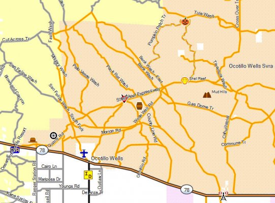
Ocotillo Wells GPS Map for Garmin Receivers
Maps!
1. Map of the area:
http://ohv.parks.ca.gov/pages/1170/files/OcotilloMap_WEB.pdf
2. Blow Sand dot com map:
Ocotillo Wells SVRA Map
3. GPS map for Garmin receivers:
Anza-Borrego Explorer - A GPS Map for Garmin Receivers
Anza-Borrego Explorer - Ocotillo Wells State Vehicular Recreation Area
4. Topo map
Ocotillo Wells State Vehicular Recreation Area Topo Map
---------- Post added at 08:20 AM ---------- Previous post was at 08:15 AM ----------
OW trail map
http://www.anzaborregoexplorer.com/MapCoverage/images/OcotilloWellsMap-Wide.JPG


