You are using an out of date browser. It may not display this or other websites correctly.
You should upgrade or use an alternative browser.
You should upgrade or use an alternative browser.
NAVIGATION - Instruction Has Begun
- Thread starter John M BUNMAN
- Start date
Disclaimer: Links on this page pointing to Amazon, eBay and other sites may include affiliate code. If you click them and make a purchase, we may earn a small commission.
Oldfart
FRF Addict
- Joined
- Oct 21, 2017
- Posts
- 6,077
- Reaction score
- 15,171
Great thread! Thanks for making it. It's always nice to learn from an experienced expert. I only ever got truly lost one time. I was deer hunting when I was about 21, in a really large deep woods area on a cold, windy, and very overcast day. I was taught to always trust my compass. I had a good map, I was comfortable in the woods, after an hour of walking, the area I was in did not make any sense. Check map. take another reading, keep walking. Repeat last step quite a few more times. I had water and food. Another long stretch of walking and NOTHING is making sense. Check my compass for about the 10th time. I would put it on the ground and step back a few feet so my gear couldn't fudge the reading. This last time I picked it up and set it down again to double-check my reading.
I finally realize my compass has shit the bed! I figured out the compass was just giving random readings and would point a different direction every time you put it down! As I had no idea where I was at this point, I sat down and ate, drank some water and decided it's not a great feeling to have very little idea where you are. I decided to walk as straight a line as I could until I got to something I could recognize. About 2 hours later I came to a pipeline and knew roughly where I was. I knew Rt 80 was a few miles south of where I was, so I hiked down there and hitch hiked a ride with a kind soul who didn't mind stopping for a guy with a rifle.
I had never thought about my compass failing!

Last edited:
Hey, Death Hollow. One of the better backpack trips of my life was down Death Hollow from the Devil's Backbone road to the river and back up the Slickrock Saddle Bench to make a loop. What incredible country.
John M BUNMAN
BUNMAN-Adventures, Rescue & Recovery
You got that right brother!! I could spend the rest of my life Base camping Escalante or Kanab!! Did you get down Hole in the Rock? Some incredible sights and Slots down there.Hey, Death Hollow. One of the better backpack trips of my life was down Death Hollow from the Devil's Backbone road to the river and back up the Slickrock Saddle Bench to make a loop. What incredible country.
John M BUNMAN
BUNMAN-Adventures, Rescue & Recovery
You got that right, throw in Intersection, Resection, Grid to Magnetic and Terrain Association and you loose another 1 1/2%I did "orienteering" in an 8th grade camp. I understand the basics of how to navigate with a compass and a topographical map.
that skill is lost to 98% of the world
Did you get down Hole in the Rock? Some incredible sights and Slots down there.
I have. Driven there, boated there, done many of the slots from the road and from the lake. It's too bad the lake is so low these days, it's much nicer when it's full.
John M BUNMAN
BUNMAN-Adventures, Rescue & Recovery
Spot on my brother. I have all trails too but I use it mainly to recon hikes in the area I’m in at the time. I think you will love GAIA it has Several different Overlays you can use on it. A 4x4 trail map app just paired with them and you can use their Overlay now. You can zoom into a 20’ over view, I believe 2k’ or less of zoom brings in the Contour Lines and minor trails and roadsGrew up on maps. Usually like to have a couple of whatever area - USGS, trail topo... Topography and elevation indicators can be different in various maps.
I'll take a look at GAIA. Usually use AllTrails and OnX Hunt/Backcountry for on-foot. Always carry the paper though.
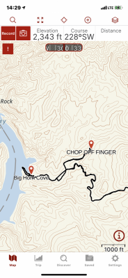
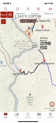
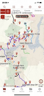
John M BUNMAN
BUNMAN-Adventures, Rescue & Recovery
Great thread! Thanks for making it. It's always nice to learn from an experienced expert. I only ever got truly lost one time. I was deer hunting when I was about 21, in a really large deep woods area on a cold, windy, and very overcast day. I was taught to always trust my compass. I had a good map, I was comfortable in the woods, after an hour of walking, the area I was in did not make any sense. Check map. take another reading, keep walking. Repeat last step quite a few more times. I had water and food. Another long stretch of walking and NOTHING is making sense. Check my compass for about the 10th time. I would put it on the ground and step back a few feet so my gear couldn't fudge the reading. This last time I picked it up and set it down again to double-check my reading.
I finally realize my compass has shit the bed! I figured out the compass was just giving random readings and would point a different direction every time you put it down! As I had no idea where I was at this point, I sat down and ate, drank some water and decided it's not a great feeling to have very little idea where you are. I decided to walk as straight a line as I could until I got to something I could recognize. About 2 hours later I came to a pipeline and knew roughly where I was. I knew Rt 80 was a few miles south of where I was, so I hiked down there and hitch hiked a ride with a kind soul who didn't mind stopping for a guy with a rifle.
I had never thought about my compass failing!
WTF, glad you made it out safely. That could have been a COLD night in hyperthermia village!
I’ve been doing this for a bit and have never heard of a compass failing. Great now I have to carry a back-up compass. Good thing they are light.
Thank you for sharing Sir. You have brought us into our next lesson that ties in with pre-planning (even for a few hrs out, or a few day) and Map/GPS APP Recon. Clearly you did both which saved your azzz upon your equipment failure. You had as a reference in your mind/plan the pipeline/ rt 80 and their relationship to each other. Well Done!
John M BUNMAN
BUNMAN-Adventures, Rescue & Recovery
OldFart has brought us to our next lesson and more story time with John.
In OldFart’s example above he demonstrated two topics we have covered above in the thread. (OldFart, I forgot to ask you if anyone knew what area you were hunting had SAR needed to be activated?)
The first being Pre-Planning. Even though he was just going hunting for the day he clearly knew the area (pipeline, rt 80 and their relationship to each other) so his RECON was done.
Secondly he demonstrated our point of EVERYTHING WILL FAIL AT SOMETIME, usually when you need it most(see Murphy’s Law).
Today’s Lesson is- ESCAPE AZIMUTH
What is an AZMUTH?
In navigationEdit
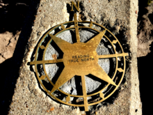
Azimuth Marker, Mount Allen (Sandstone Peak), Southern California, USA.
In land navigation, azimuth is usually denoted alpha, α, and defined as a horizontal angle measured clockwise from a north base line or meridian.[3][4] Azimuth has also been more generally defined as a horizontal angle measured clockwise from any fixed reference plane or easily established base direction line.[5][6][7]
Today, the reference plane for an azimuth is typically true north, measured as a 0° azimuth, though other angular units (grad, mil) can be used. Moving clockwise on a 360 degree circle, east has azimuth 90°, south 180°, and west 270°. There are exceptions: some navigation systems use south as the reference vector. Any direction can be the reference vector, as long as it is clearly defined.
Quite commonly, azimuths or compass bearings are stated in a system in which either north or south can be the zero, and the angle may be measured clockwise or anticlockwise from the zero. For example, a bearing might be described as "(from) south, (turn) thirty degrees (toward the) east" (the words in brackets are usually omitted), abbreviated "S30°E", which is the bearing 30 degrees in the eastward direction from south, i.e. the bearing 150 degrees clockwise from north. The reference direction, stated first, is always north or south, and the turning direction, stated last, is east or west. The directions are chosen so that the angle, stated between them, is positive, between zero and 90 degrees. If the bearing happens to be exactly in the direction of one of the cardinal points, a different notation, e.g. "due east", is used instead.
True north-based azimuthsEdit
From north
North 0° South 180°
North-northeast 22.5° South-southwest 202.5°
Northeast 45° Southwest 225°
East-northeast 67.5° West-southwest 247.5°
East 90° West 270°
East-southeast 112.5° West-northwest 292.5°
Southeast 135° Northwest 315°
South-southeast 157.5° North-northwest 337.5°
OK, that just gave me a migraine!
Let’s do it the ARMY WAY-KISS
An Azimuth for our needs is a Direction of travel Expressed in Degrees on your Compass.
ESCAPE AZIMUTH- Every Compass/Land NAV Course that I have done for my Uncle Samuel, you were given an ESCAPE AZIMUTH. You were to use your ESCAPE AZIMUTH only when you found yourself FUBARED. The radio traffic sounds like this “Lost 1,Lost 1 this is Lost 3 , are you Lost 2 Over.....dead air and shame?
I only had to use it once on a night course, 0200 at Ft Benning were all those FNING trees look the same, especially at night! The instructors wanted to go home and told the remaining troops to clear the course
The Escape Azimuth is a direction you can travel from ANYWHERE in your AO that will lead you to a Hardball, or known point of reference from which you can Un-F<>k yourself. OldFart did exactly that, he stayed in a straight course of travel until he found himself a known point of reference (pipeline) Your Escape Azimuth is for 2XFoot or 4x4.
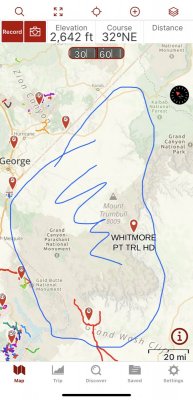
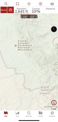
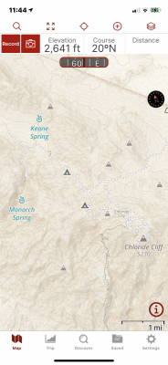
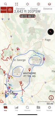
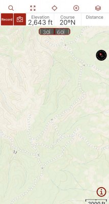
The example below is one of my favorite areas. The Grand Canyon Parashant National Monument. It’s over a million acres of Wilderness with thousands of miles of Trails and 4x4 roads. It is very easy to get turned around in there. There are some “Main Roads” coupled with hundreds of minor roads/trails and a MAZE of side/social trails and roads.
So you must have an Escape Azimuth.
You know from your Map Recon that if you head North/NW, East, or West you will find a “main road/trail” that you can use to Escape in the event of FUBARING yourself. Which EA you will use depends on which AO you are operating in at the time. ie: Mesquite side, closer to the North Rim or Kanab etc.
So let’s say over in the AO of Kanab/North Rim. I get myself FUBARED because I’ve daydreaming, looking at all the pretty sights, taking turn after turn and then????
If I head N or E I will hit a hardball. I go down this road heading NE and I come to a Y or T road junction?? You continue in the direction that heads towards your EA direction that you have chosen for your “tactical withdrawal” hence saving face with your wife/loved ones/chippy/ yourself. I meant to do that
In OldFart’s example above he demonstrated two topics we have covered above in the thread. (OldFart, I forgot to ask you if anyone knew what area you were hunting had SAR needed to be activated?)
The first being Pre-Planning. Even though he was just going hunting for the day he clearly knew the area (pipeline, rt 80 and their relationship to each other) so his RECON was done.
Secondly he demonstrated our point of EVERYTHING WILL FAIL AT SOMETIME, usually when you need it most(see Murphy’s Law).
Today’s Lesson is- ESCAPE AZIMUTH
What is an AZMUTH?
In navigationEdit

Azimuth Marker, Mount Allen (Sandstone Peak), Southern California, USA.
In land navigation, azimuth is usually denoted alpha, α, and defined as a horizontal angle measured clockwise from a north base line or meridian.[3][4] Azimuth has also been more generally defined as a horizontal angle measured clockwise from any fixed reference plane or easily established base direction line.[5][6][7]
Today, the reference plane for an azimuth is typically true north, measured as a 0° azimuth, though other angular units (grad, mil) can be used. Moving clockwise on a 360 degree circle, east has azimuth 90°, south 180°, and west 270°. There are exceptions: some navigation systems use south as the reference vector. Any direction can be the reference vector, as long as it is clearly defined.
Quite commonly, azimuths or compass bearings are stated in a system in which either north or south can be the zero, and the angle may be measured clockwise or anticlockwise from the zero. For example, a bearing might be described as "(from) south, (turn) thirty degrees (toward the) east" (the words in brackets are usually omitted), abbreviated "S30°E", which is the bearing 30 degrees in the eastward direction from south, i.e. the bearing 150 degrees clockwise from north. The reference direction, stated first, is always north or south, and the turning direction, stated last, is east or west. The directions are chosen so that the angle, stated between them, is positive, between zero and 90 degrees. If the bearing happens to be exactly in the direction of one of the cardinal points, a different notation, e.g. "due east", is used instead.
True north-based azimuthsEdit
From north
North 0° South 180°
North-northeast 22.5° South-southwest 202.5°
Northeast 45° Southwest 225°
East-northeast 67.5° West-southwest 247.5°
East 90° West 270°
East-southeast 112.5° West-northwest 292.5°
Southeast 135° Northwest 315°
South-southeast 157.5° North-northwest 337.5°
OK, that just gave me a migraine!
Let’s do it the ARMY WAY-KISS
An Azimuth for our needs is a Direction of travel Expressed in Degrees on your Compass.
ESCAPE AZIMUTH- Every Compass/Land NAV Course that I have done for my Uncle Samuel, you were given an ESCAPE AZIMUTH. You were to use your ESCAPE AZIMUTH only when you found yourself FUBARED. The radio traffic sounds like this “Lost 1,Lost 1 this is Lost 3 , are you Lost 2 Over.....dead air and shame?
I only had to use it once on a night course, 0200 at Ft Benning were all those FNING trees look the same, especially at night! The instructors wanted to go home and told the remaining troops to clear the course
The Escape Azimuth is a direction you can travel from ANYWHERE in your AO that will lead you to a Hardball, or known point of reference from which you can Un-F<>k yourself. OldFart did exactly that, he stayed in a straight course of travel until he found himself a known point of reference (pipeline) Your Escape Azimuth is for 2XFoot or 4x4.
The example below is one of my favorite areas. The Grand Canyon Parashant National Monument. It’s over a million acres of Wilderness with thousands of miles of Trails and 4x4 roads. It is very easy to get turned around in there. There are some “Main Roads” coupled with hundreds of minor roads/trails and a MAZE of side/social trails and roads.
So you must have an Escape Azimuth.
You know from your Map Recon that if you head North/NW, East, or West you will find a “main road/trail” that you can use to Escape in the event of FUBARING yourself. Which EA you will use depends on which AO you are operating in at the time. ie: Mesquite side, closer to the North Rim or Kanab etc.
So let’s say over in the AO of Kanab/North Rim. I get myself FUBARED because I’ve daydreaming, looking at all the pretty sights, taking turn after turn and then????
If I head N or E I will hit a hardball. I go down this road heading NE and I come to a Y or T road junction?? You continue in the direction that heads towards your EA direction that you have chosen for your “tactical withdrawal” hence saving face with your wife/loved ones/chippy/ yourself. I meant to do that


Oldfart
FRF Addict
- Joined
- Oct 21, 2017
- Posts
- 6,077
- Reaction score
- 15,171
WTF, glad you made it out safely. That could have been a COLD night in hyperthermia village!
I’ve been doing this for a bit and have never heard of a compass failing. Great now I have to carry a back-up compass. Good thing they are light.
Thank you for sharing Sir. You have brought us into our next lesson that ties in with pre-planning (even for a few hrs out, or a few day) and Map/GPS APP Recon. Clearly you did both which saved your azzz upon your equipment failure. You had as a reference in your mind/plan the pipeline/ rt 80 and their relationship to each other. Well Done!
I was definitely thinking I might be doing a December winter night in the woods. Obviously that was way before portable phones. I would start my hunt at a "closed for the winter" ranger station, I would park there. When I came out I would call family from a phone booth (remember those? lol) and tell them I'm out. I never thought of a compass crapping out either. Even my dive compasses have never died.
Similar threads
- Replies
- 0
- Views
- 240
- Replies
- 0
- Views
- 162
Members online
- AvaLaunch3R
- CleverGirl_
- NashR
- Levi Kastner
- yonikap
- GCATX
- efergus11
- jzweedyk
- Gdog
- scpete24
- Trident1
- elking
- GAMike
- MurderedOutSVT
- FJohnny
- pat247
- youngmb
- Johnny@Apollo-Optics
- twin001
- sdfd504
- Sharpie69
- Irregular F150
- Marcos1
- tcm glx
- stuntshow509
- ToadSmasher2K1
- B Scott
- jk47
- jond
- SpiderBat2099
- mleaky
- KustomAF
- MDJAK
- dacrepair
- Spike Spiegel
- Badboy4fun_wa
- NES431
- Trail_Rider
- Space Ghost
- taquitos
- guiltyRaptor
- Ol Blu
- jp0319
- Keith88
- drtibrd
- TomDirt
- TiFJ
- StuartR
- DFS
- bytorrush
Total: 5,197 (members: 81, guests: 5,116)

