Ok everyone, I want to say this one more time, this is not so much of a TRAIL as it is a ROUTE. The "T " in trail make **** sound better than TWAR, with that said, this ROUTE was created by motorcycle guys running those BMW offroad bikes. We were able to find a KMZ file that someone made that shows a path that Trucks can make. I think Tom posted a link to the **** website. The route was made to traverse from the Illinois border north to Lake Superior with a minimum amount of time on paved 4 lane roads. I would say that in the 225 miles I have driven of the 660 entire miles ( from Black River Falls south to the Illinois border there was 25% paved 2 lane asphalt stripped road, 25% 2 lane asphalt no stripes, 20% tar and chip roads, 25% gravel / dirt roads and 5% dirt road or two tracks. Lots of left and right turns, sometimes you think your just drove in a big circle. We started looking at this run as a "Fall Colors" run to keep the wives involved. Steve and I had a great time a few weeks ago scouting. Lots of places to go fast and places to drift. All of it is on public roads. I just don't want someone to say, I though we were going offroading. Go to the dunes or the badland or Baldwin, This is a Sunday drive with friends. Enough said....
This is a great way to explain this trip thanks Keith!!
That being said I am doing a lot of research into the road surfaces of roads to try and find the best route for us to take traveling over as little paved surface as possible. I have printed and colorized all the road maps from the forest service for the Chequamegon and Nicolet National Forests and have been using google earth imagery to try to evaluate road surfaces on those routes.
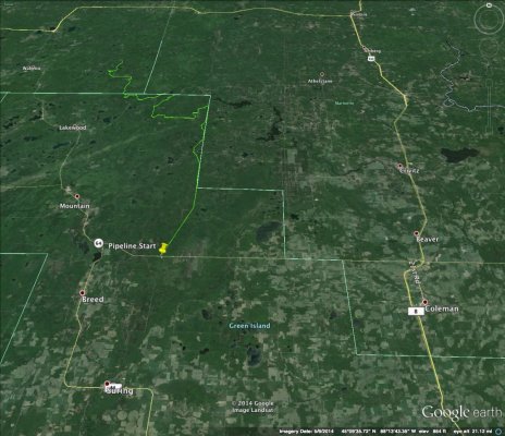
Open option I have found is that if we meet with the MN group in Wausau there is a forest service road known as the pipeline trail that starts around 70 miles NEE of Wausau. This is still a public road but should be one of the more fun sections we would encounter on the route (in WI), the road runs for around 17-18 miles north. After this we have a couple of options (research in progress):
1) Continue north for around 2 hours on forest service roads to Ottawa National forest where there are a large network of real trails, for which I am collecting some maps. Which we would then use to head west back into WI finding somewhere to camp for the night (probably a FS campground in or around Chequamegon National Forest). We will be able to cover some of the route taken in option 2 on Sunday as we head back south.
2) Take a loop through American Legion State Forest, Northern Highland State Forest and Chequamegon National Forest to end up back in the Chippewa Falls area for the evening.
Now the question for you all is which of these sounds more interesting to you?
Note: Option 1 will probably require SCABs to carry 2 extra 5Gal fuel cans, and SCREWs one.
Oh and participant list has been updated.


