BigJ
FRF Addict
- Joined
- Aug 5, 2010
- Posts
- 5,448
- Reaction score
- 1,561
I think I *finally* have something figured out for my specific needs that I can live with. Its by no means perfect, and I plan to make a few tweaks along the way, but I think I'm on the right track here. 'Bout time!
UPDATE: Nooooope! I was wrong; this aint a solution I can live with. If you're looking for a similar solution please make sure you read this entire thread. This is an evolving project!
Hardware:
1x Acer A200 Android 16GB 10.1" ICS Tablet @ $350 (it has a built in full blown GPS and antenna):
Amazon.com: Acer Iconia A200-10g16u 10.1-Inch Screen Tablet - Titanium Gray: Computers & Accessories
1x POSRUS Antiglare Antifingerprint Screen Protector @ $10 (not yet installed but as you can tell, totally required):
Amazon.com: POSRUS Antiglare Antifingerprint Screen Protector for Acer Iconia A200 Tablet **ONLY SOLD BY POSRUS**: Electronics
2x Ram Mount 3.25" suction cups w/ 1" ball @ $19ea:
Suction Cup Base - 3.25" Diameter Suction Cup with 1" Ball
1x Ram Mount 3" double socket arm for 1" ball @ $14ea:
RAM Double Socket Arm for 1" Ball Bases
Total hardware cost: $420ish
Software:
On road / offline navigation = CoPilot Live USA @ $10:
http://goo.gl/xunST
Off road / offline "navigation" = AlpineQuest @ $6:
http://goo.gl/iQHq7
Map creator for off road / offline use = Mobile Atlas Creator @ Free:
Mobile Atlas Creator (MOBAC)
Total software cost: $16
Total solution cost: $440ish
Hardware explained:
I have tried all sorts of ideas so far; my Android phone, dedicated handheld GPSs, dedicated panel mount GPSs, smaller Android tablets and on and on. For me and my puroses, I kept coming back to my phone as the solution. I liked the software and its interface, I liked that it had the most up to date maps and POIs, and I liked the idea of not spending big bucks on a dedicated unit. But I hated the small screen for navigating and having to constantly pick it up, take my eyes off the road and focus on that little screen. So I gave a 7" tablet mounted to the windshield a try, and I felt I was getting close. However, the particular tablet I tried (Lenovo Ideapad A1) isn't sunlight readable, and not near bright enough not to wash out mid day. I also ran into charging issues since it wants to use USB as its charging port, and the USB ports we have available to us for a "hardwired" solution aren't strong enough.
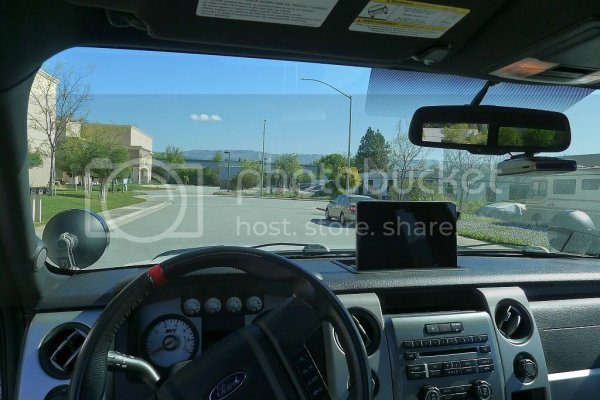
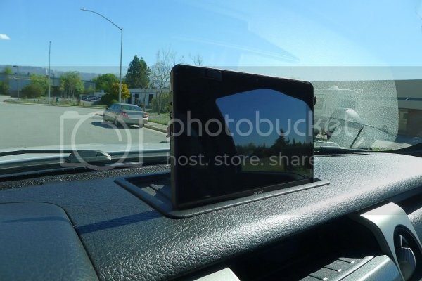
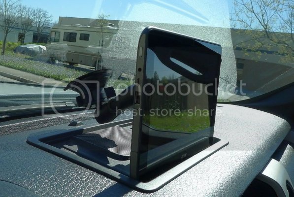
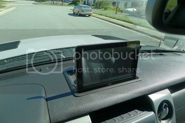
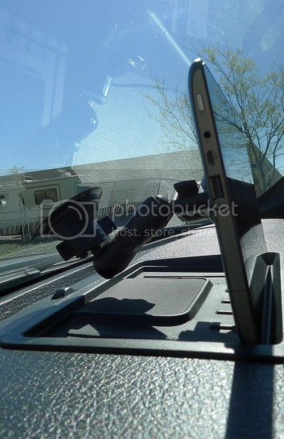
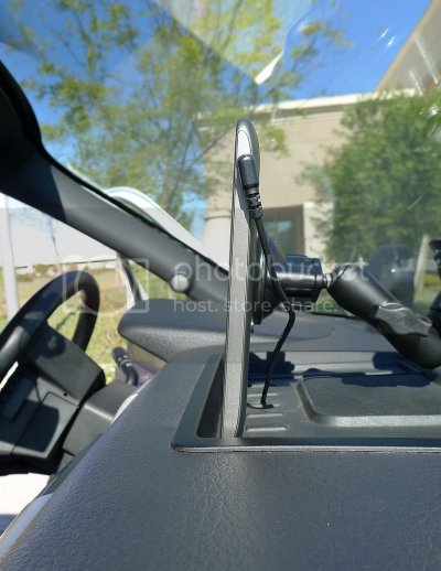
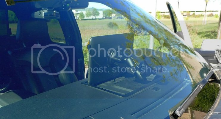
So did some homework, took some measurements and discovered the A200. Its still not sunlight readable, but its FAR brighter than the Lenovo making it passably readable in direct sunlight. It also happens to fit like a glove in our center speaker area (see the pics). This allows me to use the suction cup mount for positioning, but not for weight bearing. The result is no floating in space and no gitter. Sweet! And as for the charging, it has a dedicated port for it and comes with a 12v wall wort. I cut off the wort part, and hard wired the cable thru my speaker panel, and down to the cig adapter up on the console. A few snips and twists later and I have full 12v @ 5a on demand; plenty of power to keep this tab happy.
The other benefit for me of this approach is I basically now don't need to take my laptop on these trips any more. I can use this tablet as my connected device should the need arise, and even get some work done if required via tools like LogMeIn and such.
As for visibility, by setting the tablet inside the center speaker area, its *almost* as low as the Lowrance Elite was inside the Outlaw Raptor mount. Honestly I don't feel like I'm giving anything up from a safety perspective with how this sits, although it had taken some time to get used to up there. However, having said that, maybe a 7" with a better screen would be preferable... I'd bet a 7" in that same spot wouldn't even crest over the hoodline, although obviously it wouldn't fit nearly as well in the center speaker area as does the 10.1". Either way and as a bonus, you can tuck that suction cup in there like I did and ya don't see it from inside the cab. Nice and clean.
One more note on the hardware: I was hoping to make this entire solution also function as a black box / dash cam using software like DailyRoads Voyager (http://goo.gl/XtzaN @ free). Unfortunately the A200 has no rear camera so that option is out. Given the other benefits, I figure its an ok compromise, but with all these new sub $300 10.1"ers due to hit the market in the next few months, maybe the 'next' gen will have a cam back there. I'll be keeping my eyes open, for sure.
Software explained:
I have litereally explored a dozen different software solutions over the past couple of months. The good news is for offline on road stuff, there are a handful of great choices to pick from. Basically, pick one you like since you can't really go wrong.
On the other hand, there seem to be only one or two Android apps that do what I want them to do off road. Specifically:
-offline maps for terrain, topo and/or satelite
-record tracks live
-allow easy 1-press waypoint adding
-display old tracks and waypoints as a sort of breadcrumb trail
-"navigate" between waypoints. I'm very comfortable and fimilar with those first four, but this one is kind of a new idea to me. I'd like to explore it as I go, so I wanted to make sure the software could do it.
After all is said and done, I found that Backcountry Navigator Pro (http://goo.gl/9CbDh @ $10) and AlpineQuest (http://goo.gl/iQHq7 @ $6) can do all four extremely well, but AlpineQuest can also "navigate". So that's where I landed.
Here's the rub though: both of these programs will download maps on the fly as you're viewing and area, and both will also let you save an area's maps for offline use. However, both depend on other people's maps! Unlike on road navigation, where (for example) when you download CoPilot you're also given the opportunity to download their USA maps, there is no such "download now" type thing for either of these programs. They expect you to, basically, source your own maps for off line use.
And that's where Mobile Atlas Creator comes in. MOBAC is an open source community driven project that runs on your WinPC, Mac or Linux box, that lets you plan layout and view all sorts of different waypoints, tracks and maps from all sorts of different sources (including Google Earth!). As you work with the tool, you select which source you want to download from, you select which area you're interested in and click "create"; the software then generates an atlas that your particular tablet software (in my case AlpineQuest) can read and use. I've created atlases for all of Anza Borrego, Ocotillo Wells, the entire Death Valley and surrounding areas, and all of the Texana Ranch for the upcoming Texas Raptor Run.
There's a ton more to it than that, but in essense MOBAC lets you pick and choose which map types you want, who you want them from and then to download them for off line use, all for free. It then lets you format those downloads for your given Android software, and then transfer them over to that device/software for use. I have to say it sounds a bit complicated, but once you get in there it really isn't. MOBAC works incredibly well and it fills a huge hole that in my mind, makes an Android based solution viable. Without MOBAC, IMHO trying to make an android solution work in off line mode is an exercise in futility as of today.
I haven't had the chance to test all this off road yet, but really I'd be surprised if anything pops up that I haven't already addressed. I always carry a physical map and compass for emergencies, I have all these same softwares and maps on my Android phone should the tablet fail, and I have the tablet running should all go smashingly well. For me and my goals, I think I've finally figured all this crap out
UPDATE: Nooooope! I was wrong; this aint a solution I can live with. If you're looking for a similar solution please make sure you read this entire thread. This is an evolving project!


Hardware:
1x Acer A200 Android 16GB 10.1" ICS Tablet @ $350 (it has a built in full blown GPS and antenna):
Amazon.com: Acer Iconia A200-10g16u 10.1-Inch Screen Tablet - Titanium Gray: Computers & Accessories
1x POSRUS Antiglare Antifingerprint Screen Protector @ $10 (not yet installed but as you can tell, totally required):
Amazon.com: POSRUS Antiglare Antifingerprint Screen Protector for Acer Iconia A200 Tablet **ONLY SOLD BY POSRUS**: Electronics
2x Ram Mount 3.25" suction cups w/ 1" ball @ $19ea:
Suction Cup Base - 3.25" Diameter Suction Cup with 1" Ball
1x Ram Mount 3" double socket arm for 1" ball @ $14ea:
RAM Double Socket Arm for 1" Ball Bases
Total hardware cost: $420ish
Software:
On road / offline navigation = CoPilot Live USA @ $10:
http://goo.gl/xunST
Off road / offline "navigation" = AlpineQuest @ $6:
http://goo.gl/iQHq7
Map creator for off road / offline use = Mobile Atlas Creator @ Free:
Mobile Atlas Creator (MOBAC)
Total software cost: $16
Total solution cost: $440ish
Hardware explained:
I have tried all sorts of ideas so far; my Android phone, dedicated handheld GPSs, dedicated panel mount GPSs, smaller Android tablets and on and on. For me and my puroses, I kept coming back to my phone as the solution. I liked the software and its interface, I liked that it had the most up to date maps and POIs, and I liked the idea of not spending big bucks on a dedicated unit. But I hated the small screen for navigating and having to constantly pick it up, take my eyes off the road and focus on that little screen. So I gave a 7" tablet mounted to the windshield a try, and I felt I was getting close. However, the particular tablet I tried (Lenovo Ideapad A1) isn't sunlight readable, and not near bright enough not to wash out mid day. I also ran into charging issues since it wants to use USB as its charging port, and the USB ports we have available to us for a "hardwired" solution aren't strong enough.
So did some homework, took some measurements and discovered the A200. Its still not sunlight readable, but its FAR brighter than the Lenovo making it passably readable in direct sunlight. It also happens to fit like a glove in our center speaker area (see the pics). This allows me to use the suction cup mount for positioning, but not for weight bearing. The result is no floating in space and no gitter. Sweet! And as for the charging, it has a dedicated port for it and comes with a 12v wall wort. I cut off the wort part, and hard wired the cable thru my speaker panel, and down to the cig adapter up on the console. A few snips and twists later and I have full 12v @ 5a on demand; plenty of power to keep this tab happy.
The other benefit for me of this approach is I basically now don't need to take my laptop on these trips any more. I can use this tablet as my connected device should the need arise, and even get some work done if required via tools like LogMeIn and such.
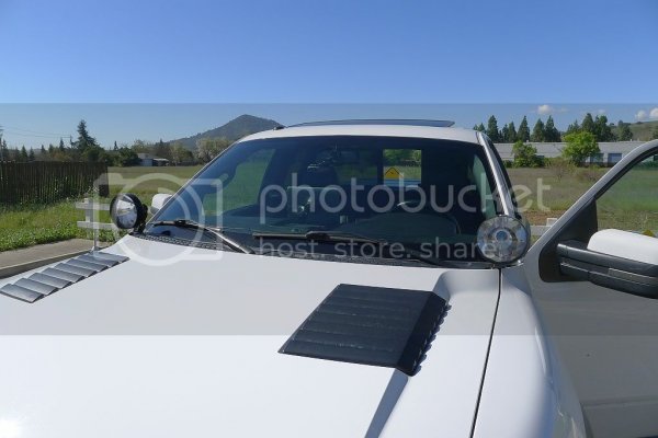
As for visibility, by setting the tablet inside the center speaker area, its *almost* as low as the Lowrance Elite was inside the Outlaw Raptor mount. Honestly I don't feel like I'm giving anything up from a safety perspective with how this sits, although it had taken some time to get used to up there. However, having said that, maybe a 7" with a better screen would be preferable... I'd bet a 7" in that same spot wouldn't even crest over the hoodline, although obviously it wouldn't fit nearly as well in the center speaker area as does the 10.1". Either way and as a bonus, you can tuck that suction cup in there like I did and ya don't see it from inside the cab. Nice and clean.
One more note on the hardware: I was hoping to make this entire solution also function as a black box / dash cam using software like DailyRoads Voyager (http://goo.gl/XtzaN @ free). Unfortunately the A200 has no rear camera so that option is out. Given the other benefits, I figure its an ok compromise, but with all these new sub $300 10.1"ers due to hit the market in the next few months, maybe the 'next' gen will have a cam back there. I'll be keeping my eyes open, for sure.
Software explained:
I have litereally explored a dozen different software solutions over the past couple of months. The good news is for offline on road stuff, there are a handful of great choices to pick from. Basically, pick one you like since you can't really go wrong.
On the other hand, there seem to be only one or two Android apps that do what I want them to do off road. Specifically:
-offline maps for terrain, topo and/or satelite
-record tracks live
-allow easy 1-press waypoint adding
-display old tracks and waypoints as a sort of breadcrumb trail
-"navigate" between waypoints. I'm very comfortable and fimilar with those first four, but this one is kind of a new idea to me. I'd like to explore it as I go, so I wanted to make sure the software could do it.
After all is said and done, I found that Backcountry Navigator Pro (http://goo.gl/9CbDh @ $10) and AlpineQuest (http://goo.gl/iQHq7 @ $6) can do all four extremely well, but AlpineQuest can also "navigate". So that's where I landed.
Here's the rub though: both of these programs will download maps on the fly as you're viewing and area, and both will also let you save an area's maps for offline use. However, both depend on other people's maps! Unlike on road navigation, where (for example) when you download CoPilot you're also given the opportunity to download their USA maps, there is no such "download now" type thing for either of these programs. They expect you to, basically, source your own maps for off line use.
And that's where Mobile Atlas Creator comes in. MOBAC is an open source community driven project that runs on your WinPC, Mac or Linux box, that lets you plan layout and view all sorts of different waypoints, tracks and maps from all sorts of different sources (including Google Earth!). As you work with the tool, you select which source you want to download from, you select which area you're interested in and click "create"; the software then generates an atlas that your particular tablet software (in my case AlpineQuest) can read and use. I've created atlases for all of Anza Borrego, Ocotillo Wells, the entire Death Valley and surrounding areas, and all of the Texana Ranch for the upcoming Texas Raptor Run.
There's a ton more to it than that, but in essense MOBAC lets you pick and choose which map types you want, who you want them from and then to download them for off line use, all for free. It then lets you format those downloads for your given Android software, and then transfer them over to that device/software for use. I have to say it sounds a bit complicated, but once you get in there it really isn't. MOBAC works incredibly well and it fills a huge hole that in my mind, makes an Android based solution viable. Without MOBAC, IMHO trying to make an android solution work in off line mode is an exercise in futility as of today.
I haven't had the chance to test all this off road yet, but really I'd be surprised if anything pops up that I haven't already addressed. I always carry a physical map and compass for emergencies, I have all these same softwares and maps on my Android phone should the tablet fail, and I have the tablet running should all go smashingly well. For me and my goals, I think I've finally figured all this crap out
Last edited:


