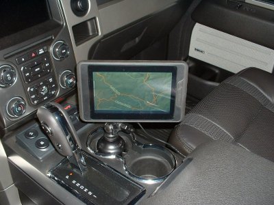
Off road navigation

Disclaimer: Links on this page pointing to Amazon, eBay and other sites may include affiliate code. If you click them and make a purchase, we may earn a small commission.

everestm

Member
Joined
Feb 3, 2019
Posts
7
Reaction score
5
Location
Los Angeles
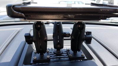
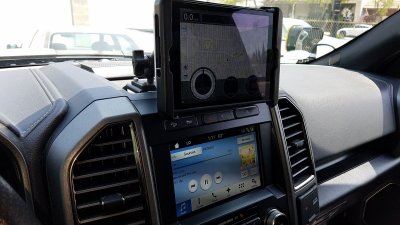
Finally got everything working. I used a Builtright dash mount kit, ball mounts and arm from Ram, a new iPad, and a Dual GPS receiver. Purchased the mid-range LeadNav map upgrade and so for I am enjoying this setup. The real test will be this weekend, we’re going out into the desert. It did take a looooonnnnnnggggggg time to download the maps for where we are going, but I’m sure it will be nice to have decent maps and nav.

View attachment 122075

View attachment 122076


I have the same BuiltRight rack. How is it doing supporting the weight of an iPad? I've been wary of using an iPad attached like that for offroading purposes.
 

Loufish

FRF Addict
Joined
Dec 30, 2017
Posts
1,050
Reaction score
642
Location
Burbank CA
Actually I run an Ipad mini..I didn't want to deal with weight issues whatever mount used...I bought the Ipad to run Lednav and spent some time watching vids on how to get the most out of it...
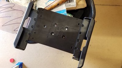
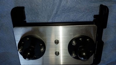
Mounting: I went with a RAM spring loaded mount that uses one 1" ball....and after time it would creep down. So I did a custom job of the RAM Ipad mount by adding 1 more ball so now there's 2 ball's to keep it in place - Works great!

Ipad Mount2.jpg

Ipad Mount3.jpg

Ipad Mount5.jpg

Ipad Mount6.jpg
 

Kahuna

THE MORE YOU PLAY WITH IT, THE BIGGER IT GETS
Joined
Aug 31, 2014
Posts
872
Reaction score
795
One ram ball has been doing the trick for me with an iPad mini for years. Just crank down on that sucker hard. Motion X is our default app. Downloading Maps is still painful but nothing like the absurdity of Leadnav.
 

SS308

FRF Supporting Member
Supporting Member
Joined
Dec 31, 2018
Posts
931
Reaction score
571
Location
Cheyenne, Wyoming
I like and use the Magellan TR7 with the Built Right mounting system. It also offers the satellite images.
 

jaytperry

Full Access Member
Joined
Dec 3, 2016
Posts
51
Reaction score
48
Location
Idaho falls Idaho
I use a tablet, and run backcountry navigator. One time fee with the app, there is subscription addons like BLM and private land boundaries. Works great for me
 

dilmorecg

Full Access Member
Joined
Jan 8, 2019
Posts
127
Reaction score
52
Location
Seattle, WA
I use Avenza Maps app. Similar with the other ones suggested you can download the map area that you are going and it uses your phones GPS to pin point you on the map. Started using this for mountain biking and you can download a lot of map areas around where I am for offroading.
 

NHbeast

Full Access Member
Joined
Jul 11, 2018
Posts
281
Reaction score
205
Location
Merrimack Valley
I have a Garmin Zumo 650.
Use it on the motorcycle mostly.
On a recent trip into the wilderness mounted it to the windshield just below the rear view mirror on a suction mount.
Also had an IPad mini with hi rez topo maps loaded of the area which sat on the steering column when appropriate.
Plus the Nav unit in the truck, most bases were covered.
Could have had a two way radio and/or a Spot for emergencies...next time, maybe.
The stock unit drops cookies as does the Garmin to keep track of where you have been if backtracking is needed.
FWIW
 
Top